News · Environment & Climate
Almost 300,000 people now live in flood‑prone areas in the Nepalese Himalayas—new research
A place is flood-prone when its position makes it potentially exposed to flooding. For a person, living or working there means floodwaters could reach them during a hazardous event. Exposure does not guarantee that flooding will happen, but it identifies possible danger zones. In Himalayan valleys, rivers, debris flows and sudden lake breaches follow natural channels and low-lying routes. A building beside a river may be much more exposed than one nearby on higher ground. The researchers used height above nearest drainage to estimate this difference. Flood-prone does not automatically mean disaster-prone. Building strength, warning systems, preparedness and evacuation plans affect the outcome. However, the study found that more people and infrastructure are entering these potentially exposed areas, increasing the importance of careful land-use and infrastructure planning.
Based on reporting by Phys.org
What does it mean for a place or person to be “flood-prone”?
A place is flood-prone when its position makes it potentially exposed to flooding. For a person, living or working there means floodwaters could reach them during a hazardous event. Exposure does not guarantee that flooding will happen, but it identifies possible danger zones.
In Himalayan valleys, rivers, debris flows and sudden lake breaches follow natural channels and low-lying routes. A building beside a river may be much more exposed than one nearby on higher ground. The researchers used height above nearest drainage to estimate this difference.
Flood-prone does not automatically mean disaster-prone. Building strength, warning systems, preparedness and evacuation plans affect the outcome. However, the study found that more people and infrastructure are entering these potentially exposed areas, increasing the importance of careful land-use and infrastructure planning.
How many people now live in potentially flood-prone areas of the Nepalese Himalayas, and how much did exposed built-up land increase between 2016 and 2023?
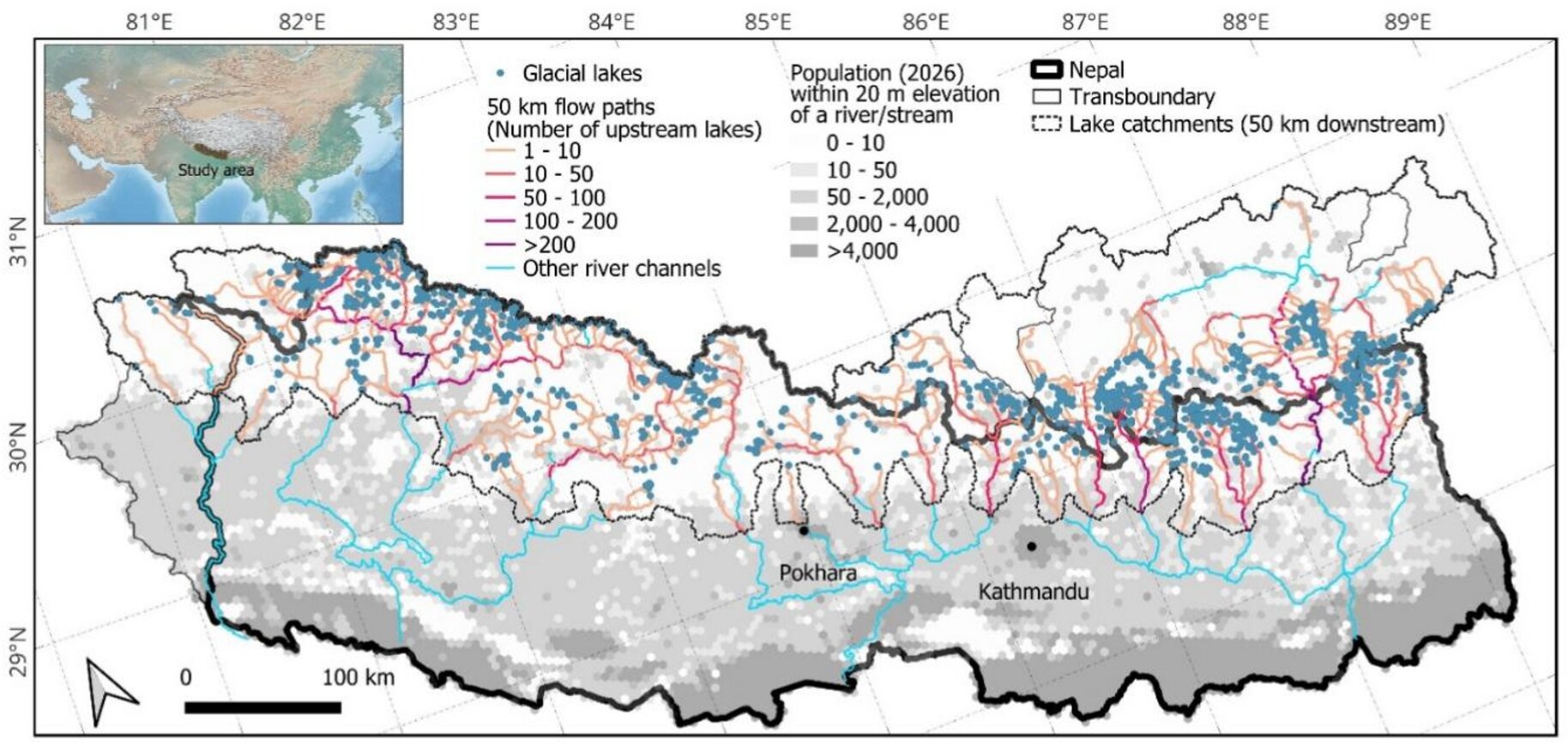
The study estimates that almost 300,000 people live in potentially flood-prone areas across the Nepalese Himalayas. More than 100,000 of them live downstream from glacial lakes, where a sudden breach could release powerful floodwaters. These figures show that exposure is not limited to remote, empty mountain landscapes.
Built-up areas potentially exposed to flooding increased by 46% between 2016 and 2023. The researchers studied Nepal and the catchment areas of rivers that drain into Nepal. They combined satellite-derived building data with a terrain measure called height above nearest drainage.
The increase reflects continuing development in mountain valleys. Roads, settlements, lodges, hydropower projects and public facilities are expanding along trade and tourism corridors. The study does not say all such development will flood, but it shows that decisions made now can shape disaster risk for decades.
Why are Himalayan valley floors attracting roads, settlements, hydropower projects, lodges and other infrastructure?
Himalayan valley floors are attractive because steep mountain terrain leaves few flat and accessible places for building. Roads, settlements and infrastructure need usable ground, so valleys often become the practical choice. Rivers also provide natural routes through otherwise difficult mountain landscapes.
Trade and tourism strengthen this pull. The recent disaster struck Nepal’s main trade route to China along the Bhotekoshi–Trishuli rivers. Once a road connects a valley, development often follows, including lodges, hydropower projects, homes, schools and health care facilities.
The same geography creates a serious trade-off. Valleys that make travel and construction easier are also natural pathways for floods, debris flows and landslides. As more people and buildings move into these corridors, potential exposure grows. Planning that recognizes both economic access and natural hazards could reduce future disaster risk.
What are glacial lakes, and why can a sudden breach send destructive floodwaters down a mountain valley?
Glacial lakes are bodies of water occupying depressions carved by glaciers as they retreat. As glaciers melt, these lakes can expand. Their position high in mountain catchments makes them especially important for communities and infrastructure farther downstream.
A sudden breach releases the lake’s stored water into a steep valley. The water can rapidly move downhill, following the same channels used by rivers. This can send floodwaters crashing through settlements and infrastructure below. The article identifies glacial lakes as a particular flood risk for this reason.
More than 100,000 people in the Nepalese Himalayas are estimated to live downstream of glacial lakes. Climate change is making some Himalayan hazards more dangerous, while development is increasing exposure. Identifying downstream hotspots and using that information in planning could help reduce the consequences of future breaches.
How did the researchers estimate which buildings were exposed to flooding when detailed flood maps were unavailable?
The researchers estimated exposure using height above nearest drainage, known as Hand. This metric estimates how high a building sits above the closest river channel. It helps distinguish locations that may be close horizontally but separated by large vertical differences.
That distinction matters in steep Himalayan valleys. Two buildings a short distance apart can stand tens of metres apart in elevation, giving them very different potential exposure. The researchers combined Hand with satellite-derived building data to track changes from 2016 to 2023.
Hand is not a replacement for detailed flood-hazard modelling. Many Himalayan valleys lack the detailed topographic data needed for that work. Instead, the measure acts as a simple screening tool for identifying exposure hotspots. It helped reveal a 46% increase in potentially exposed built-up areas during the study period.
What happens to disaster risk when new roads and settlements are built along the same valleys that carry floods, debris flows and landslides?
When roads and settlements expand along Himalayan valleys, they place more people, buildings and infrastructure near natural hazard pathways. These valleys carry rivers, but they can also channel floods, debris flows and landslides. Development therefore increases the number of things that could be damaged or affected.
A road can trigger wider growth. The article notes that roads, tracks, lodges, hydropower projects, homes, schools and health facilities often follow expanding trade and tourism corridors. Nepal’s Bhotekoshi–Trishuli route illustrates how an important transport link can also pass through a hazardous valley.
The result is rising exposure, not an inevitable disaster everywhere. Building type, warnings, preparation and evacuation planning still matter. However, the study found a 46% increase in potentially exposed built-up areas from 2016 to 2023. Future planning can prevent new development from becoming part of future disaster zones.
How do climate hazards, exposure, vulnerability and preparedness combine to turn a natural event into a disaster?
A climate hazard is a potentially damaging event, such as a flood, landslide or glacial-lake breach. Exposure means people, buildings or infrastructure are located where that event could reach them. Vulnerability concerns how badly those exposed people and structures may be affected.
The article shows how these factors interact in Himalayan valleys. Melting glaciers, expanding glacial lakes, thawing permafrost, landslides and heavy monsoon rain can increase hazards. At the same time, roads, homes and facilities are expanding in valley corridors. Building type, early warnings, preparedness and evacuation planning influence whether the event becomes a disaster.
Climate change is making some hazards more dangerous, but disaster risk is also shaped by settlement decisions. The study therefore points to planning as a practical way to reduce future harm. Finding high-exposure locations and guiding infrastructure away from the riskiest areas could limit losses over coming decades.
Key Facts:
📌 Flood-prone areas are locations potentially exposed to floodwaters.
📌 Valley floors can be natural pathways for floods and debris flows.
📌 Exposure is only one component of disaster risk.
📌 Almost 300,000 people live in potentially flood-prone Nepalese Himalayan areas.
📌 Potentially exposed built-up areas increased 46% from 2016 to 2023.
📌 More than 100,000 people live downstream of glacial lakes.
📌 Valley floors are among the Himalayas’ few flat, accessible building areas.